Showing posts with label technology. Show all posts

24 July 2013

3D Modeling an archaeological site during excavation

I've been playing a bit with improving the photography during excavation at the site, including better and easier overhead photos (more on that soon). This season, when I was looking at a bunch of overheads I had taken, it occurred to me that I could likely generate a decent 3D version without too much more work using the AgiSoft PhotoScan software I had purchased a few months ago.

I threw the photos into the software and got the following (which I'm showing here as a screenshot). You can see big holes where the sides of the walls are not missing due to the overhead shots being fairly vertical and therefore not capturing the sides, but overall it looks pretty good and certainly made it clear that it was possible to generate good 3D models from photos taken in a few minutes on site. So the next time, I took not only a series of overheads but also a number of shots from ground level, circling the area I was photographing while snapping shots.

Here's what that approach yielded, here in a screenshot, but for the full effect, head over to the publicly available version at p3d.in, where you want the "burial" model. I've still got to work on optimizing the conditions in the modeler for getting good results: it's easy to generate something of the quality you see here, but getting better results takes a lot more cpu time and I haven't worked out a good workflow yet. Expect some more posts on this in future weeks.

What am I going to use these for? Well, first off they look pretty cool, which is something not to be neglected. It's a lot easier to capture people's imaginations when they can play with a little 3D version of a site. Second they of course form a more sophisticated documentation of the site for human viewers. Manipulating the model helps make clear in a way that 2D photos can't how various objects related to one another. Ideally the models will eventually be of good enough quality that we can do measurements on them. You can check out the meter stick in these images already (20cm to each red and white band). We try to capture relevant locations in our total station, but it's easy to miss something and the models mean we have less to worry about. It would also be great to incorporate the digital models into our GIS system. Right now they're already useful in reminding us just what everything looked like at a certain point in time, but it should be possible to make them part of our long-term digital database.

Other people are doing this sort of thing too. For example, check out William R. Caraher's blogpost on a talk back in April and his more recent one last week and another encouraging others to blog about their work (which is in part why I wrote this!). There's a little Twitter activity too, so go have a look at @BillCaraher @adamrabinowitz @sebhth @Pompeiana79 @adreinhard.

22 May 2012

Awld.js

Just added to the blog support for the delightful javascript library for Ancient World Linked Data from my friend and colleague Sebastian Heath. (Inspired by Tom Elliott.)

Now I just have to start putting in the links (like this one to the site)!

For those watching for dig updates...one month to go!

18 September 2011

Dig website updated!

Phew. Finally got around to updating the dig website. I got inspired by the great photos by our friend Wendy Robinson, as well as the possibilities offered by Apple's nice website-creation software, iWeb. Expect to see some more updates in coming weeks, including a "testimonials" section by dig alumni. (You have been warned!)

Feedback always welcome, of course.

30 January 2011

Now on Twitter!

Since I've started using Twitter, I figured I would try to get this blog hooked up with it. So from now on, when I use the word "twitter" in a post, that should get it tweeted.

We'll see. :-)

Update: And it works!

26 June 2009

Wrapping up


Some more afternoon rain gives me the excuse to post this year's artsy photo.

Busy helping with the drawing of sections from the trenches, taking more photos of finds and various parts of the excavation, and now moving the inventory into my database.

Meanwhile we're scheduling some more meetings (mayor, potential donors) and some more visits for "remote sensing" via geo-magnetic survey and thermograph. Keep posted for results!

25 May 2009

The Gang's All Here!


Start of the second season, and everyone has arrived safely!

Very hot here in Italy, with temperatures in the low 30s (upper 80s and low 90s for those in Fahrenheit-land), but some hope of a break on Wednesday. Of course they are predicting cool weather for the weekend too.

Good news: gas is much cheaper than last year and so is the euro (which has been on the rise in the past few weeks, so let's hope that stops). We also have internet in our office/lab/storeroom in Massa Martana. (Still searching for a title for this workspace; all suggestions gratefully accepted.)

Today we went to the site, shot some points on the handy-dandy Total Station very generously loaned to us by Bryn Mawr – and ably run by Bryn Mawr '10 Sophia Wolfenden. We also have begun to run into various friends we made last year.

Tomorrow, picks hit the ground!

29 October 2008

Useful Thing with Circles


After watching one of our Italian grad students use a compass and ruler in a very impressive, but ultimately tedious way to calculate the diameter of the rim of a fragmentary vessel (= potsherd), I went on-line to search for a nice printout of concentric circles to make the job easier. Well, I found a couple, but they all printed out wrong, so I made my own this week using VectorDesigner, a decent vector-based drawing program that I got in one of those MacHeist packages.

Anyway, here's the pdf for anyone to use. Make sure that you check the scale after printing. I forgot to turn off the auto-scaling in my printer driver the first time and it ended up shrunk by a tiny bit.

Addendum 29 June 2009: Nearly a year later, I find a bunch of nicer versions of these at the bottom of this page.

24 October 2008

Google Earth

Sitting here on our GIS workshop at Drew, it occurs to me that I have never posted a Google Earth bookmark for the site. So here's one for the church of S. Maria in Pantano. We excavated just north of the church.

06 June 2008

Inscription


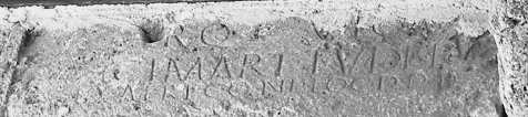
Well, as expected, all three inscriptions are in the CIL ("Corpus Inscriptionum Latinarum") volume that deals with this part of Italy, XI. Here's a photo of the inscription that gives the name of the site. I had to play with it a bit to get it to be readable (ok, mostly readable), so it appears to be in black and white, though it isn't. You can make out in the big second line "MART. TUDE" which is the middle of "Vicus Martis Tudertium", that is, "Settlement of the Mars of the people of Todi."

Sunday we plan to start the geomagnetic survey, in collaboration with Tomaso Mattioli from the University of Perugia. Should be good.

Someday the big trailer will arrive from the local town ('nuff said, if you know about Italian bureaucracy and work habits).

24 May 2008

Fun with Satellites

Drew prides itself on its incorporation of technology into learning. Me too...or maybe it's more accurate to say that I just like playing with computer stuff.

In any case, I'm incorporating a few fun technologies into the dig and courses for this summer, mainly to do with mapping. The first one relies on all those satellites the U.S. has put around the planet in order to provide itself (and incidentally the rest of us) with a fairly good idea of our position on the globe. These Global Positioning Satellites provide a constant stream of data that can be read with all sorts of GPS devices, and now I've got three of these babies: the GT-31 from Locosys. (I got mine from The Midwest Speed Quest link on that page. This is a windsurfing site: these units are waterproof and float.)

They don't show maps like the units found in cars, but they do track and store your position so that you can download it later. In fact you can create multiple tracks and save them onto an internal SD card for transfer to your computer. On your computer, you can run some free software that converts these files into numerous formats, including Google Earth's native kml and the file format for OpenStreetMap.org, which is how we're going to use them in Italy, but more on that another time.

Meanwhile, here's a screen shot from Google Earth. I got hungry and went to get some hot-and-sour soup (gratuitous unnecessary personal information, just like a real blog!), and took along the GPS unit. You can see that my path isn't perfectly mapped - I didn't stagger all over the street on my way there - but it isn't bad either. (Click on it to download the Google Earth file.)